This is a weather update being brought to you in part by both the National Weather Service and The Weather Channel in order to keep key Arandell stakeholders informed of potential travel delays due to inclement weather.
At a Glance
• Snow & wind from western and central U.S. has now reached the Northeast.
• Newly-named Winter Storm Ezekiel will hit the Northeast hard over the course of the next two days, with a high chance of travel delays expected.
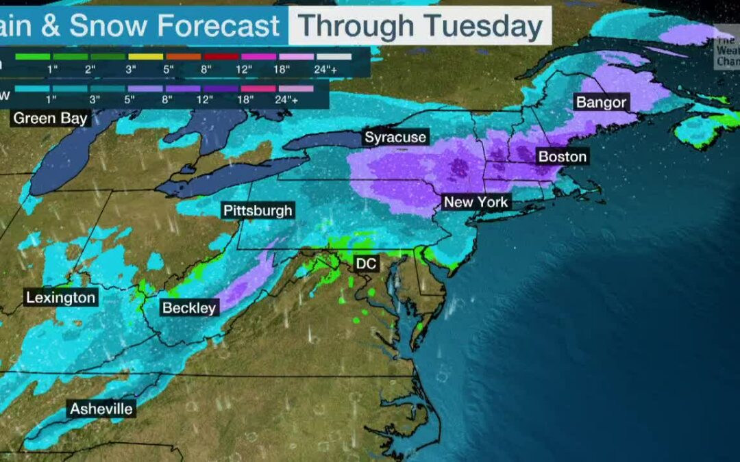
• Winter storm warnings remain in effect from northeast Pennsylvania to southern Maine, with storm total snowfall of 10 to 20 inches for some of these locations by Tuesday morning.
The trans-continental storm system that hammered the western and central U.S. over the past week with heavy snow and strong winds is now impacting the Northeast part of the U.S. at the time of this update.
Wednesday’s accurate weather forecast from last week predicted two major storms wreaking havoc over wide swaths of the country for much of the U.S. – from the sunny beaches of Southern California to the wind-whipped streets of Chicago-calls for heavy snow, rain and powerful wind gusts. Some of the worst weather was seen at peak travel times in some of the largest cities across the nation and will now be seen in many parts of the Northeast as post-Thanksgiving travels are carrying into regular daily commuting travel.
“This is not an ordinary storm,” the National Weather Service (NWS) warned.
Northeast
After sweeping across the country, the storm system is currently hammering the eastern coast. The storm system could will be pushing strong winds with 40-50 mph gusts in the forecast. More than a foot of snow has already fallen in the interior Northeast with more to be expected. The Weather Channel has already named this system Winter Storm Ezekiel, with it being the first major Northeast storm of the year.
New York Governor Andrew Cuomo has also declared a state of emergency and activated the National Guard in the following counties: Albany, Columbia, Greene, Rensselaer, Schenectady, Saratoga and Ulster.
The worst conditions are most likely in areas where winter storm warnings are already in effect — particularly areas near Albany and Syracuse, New York; Allentown and Scranton, Pennsylvania; Concord and Manchester, New Hampshire; and Bangor and Portland, Maine.
More than 6 inches of snow is expected in many of these areas with heavier totals in parts of eastern New England, meaning travel is likely to be affected.
California and the West Coast
The NWS had said a “bomb cyclone” was headed for Northern California and the southern tip of Oregon. On Wednesday morning before Thanksgiving, California shut down Interstate 5 between the northern cities of Yreka and Redding because vehicles had begun spinning out in the blizzard conditions.
Several areas throughout the Sierra Nevadas remain in a Winter Storm Warning as of Monday morning, with some areas around California’s coast maintaining High Surf and Wind Advisories.
Rockies and the Midwest
A separate yet historic snowstorm slammed Denver last Tuesday. It dumped around 10 inches of snow in Denver and nearly 3 feet of snow in parts of northern Colorado and closed long stretches of highways there and in Wyoming. The storm system then moved east and affected more of the Central to Midwestern states.
On Monday morning, most Rocky Mountain and Midwestern states had removed their weather warnings and advisories with the storm mostly having passed.
We will continue to keep our customers informed through weather updates like this so they better understand the potential impact that current conditions might have on their mailings’ in-home delivery and how their materials are currently traveling through the mail delivery supply chain. Please feel free to contact us with any additional questions.